
FLY is FUN Aviation Navigation
Elevate Your Cockpit Experience
• Designed by pilots for pilots, FLY is FUN transforms your mobile device into a professional-grade flight management system.
• We blend intuitive navigation with robust situational awareness, ensuring you stay focused on the horizon while we handle the data.
Intelligent Navigation & Planning
• Dynamic Route Planning: Easily build and modify flight paths using drag-and-drop technology.
• Virtual Avionics: Simulate ILS, VOR, NDB, RNAV, and DME navigation without the need for expensive onboard hardware.
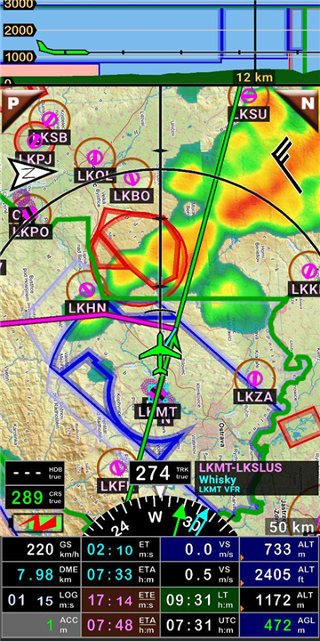
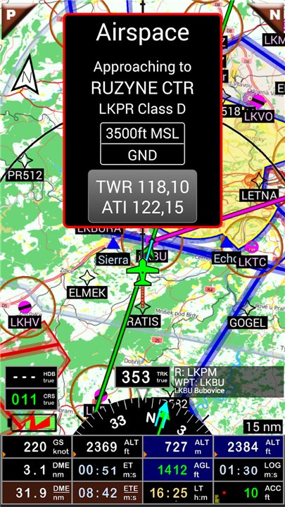
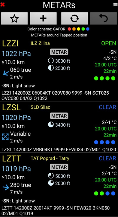
• Precision Awareness: Receive real-time audio and visual alerts for controlled airspaces, special use zones, and approaching waypoints.
• Comprehensive Metrics: Calculate fuel burn, distance, and ETA while accounting for wind and aircraft performance variables.
Integrated Situational Intelligence
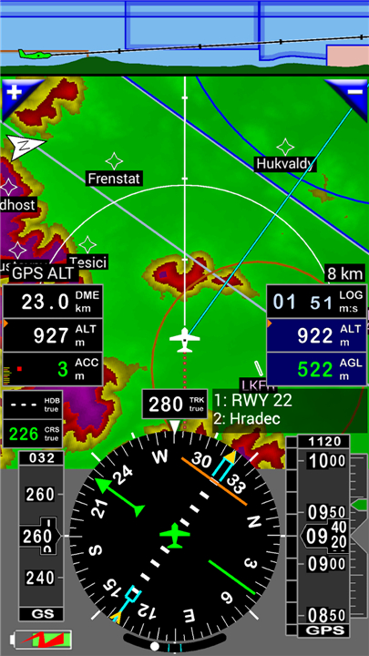
• Moving Map & Terrain: Access a dynamic, elevation-coded map that brings your surroundings to life.
• Weather & Radar: Stay ahead of the elements with live weather forecasts, wind data, and rainfall radar overlays.
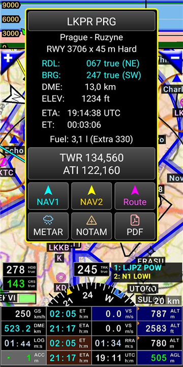
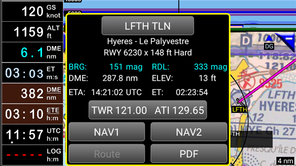
• Flight Documentation: Seamlessly access VACs, AIPs, and airport-related PDF documents for over 50 countries.
• Enhanced Connectivity: Support for STRATUX and external Bluetooth GPS devices ensures consistent, high-accuracy positioning.
Customization & Performance
• Tailored Cockpit: Choose from over 100 data points to display across 10 fully adjustable screen layouts.
• Smart Detail: Information density scales automatically with your zoom level, providing clean visuals for VFR or IFR preferences.
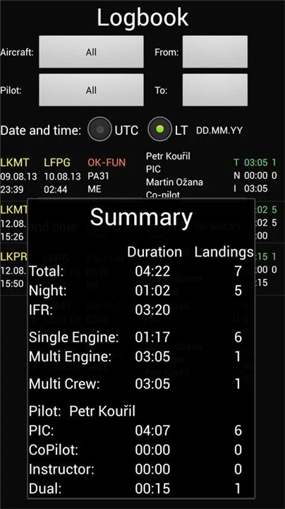
• Detailed Logbook: Automatically track flight times, routes, speeds, and crew, then export your flight path via KML or GPX for playback in Google Earth.
Charts & Data
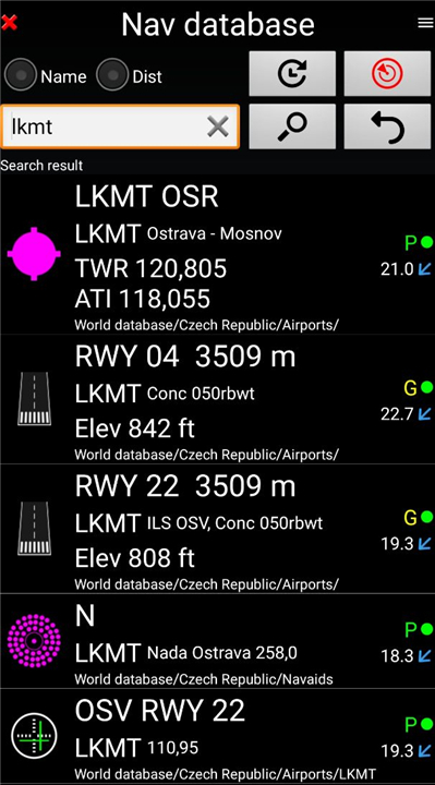
• Global Reach: Access free, AIRAC-updated open-source navigation data.
• Flexible Mapping: Choose from an extensive library of charts, including ICAO, Cartabossy, SkyVector, and FAA sectional maps. You can even import your own custom charts or request commercial integrations.
Licensing & Support
• Experience the full potential of FLY is FUN with a complimentary trial.
• Continued access is available through an annual subscription, which grants you full use of the platform and directly funds our ongoing development efforts.
Important Advisory:
• This application is intended for VFR flight only.
• Pilots bear full responsibility for the safe operation of their aircraft.
• For support, manual access, or to provide feedback, please visit www.flyisfun.com.
FAQ
Q: How does FLY is FUN help with flight planning?
A: It offers intelligent and dynamic route planning, making it incredibly easy to build and modify your flight paths using simple drag-and-drop technology. This allows for quick adjustments and efficient pre-flight preparation, ensuring your route is optimized before you even take off.
Q: Can FLY is FUN simulate professional avionics?
A: Yes, it certainly can! FLY is FUN includes virtual avionics capabilities, allowing you to simulate ILS, VOR, NDB, RNAV, and DME navigation. This means you can practice or utilize these navigation methods without the need for expensive dedicated onboard hardware in your aircraft.
Q: How does FLY is FUN keep me aware of important airspaces?
A: The application provides precision awareness by delivering real-time audio and visual alerts. It will notify you about controlled airspaces, special use zones, and approaching waypoints, helping you stay compliant and safe throughout your flight.
Version History
v35.52——5 May 2026
FLY is FUN - navigation for pilots 30 days trial version Download the latest version of FLY is FUN Aviation Navigation to enjoy new features and updates immediately!
*35.52
- Better NOTAM parsing.
- Minor dialog layouts improvements.
*35.50
- NOTAM API upgraded. It is working again.
*35.41
- Updated all language versions.
- Rainfall radar updated again. Only one color scheme is available now.
Enter or paste your release notes for en-US here
- AppSize32.39M
- System Requirements5.0 and up
- Is there a feeFree(In game purchase items)
- AppLanguage English
- Package Namegps.ils.vor.glasscockpit
- MD5910c21d731086721d04fc5eb37bd79c6
- PublisherPetr Kouřil
- Content RatingTeenDiverse Content Discretion Advised
- Privilege19
-
FLY is FUN Aviation Navigation 35.52Install
32.39M2026-07-01Updated


9.3
906 Human Evaluation
- 5 Star
- 4 Star
- 3 Star
- 2 Star
- 1 Star