-------✦ INTRODUCTION ✦------
Developed in the United States and originally released in English, HuntStand: GPS Maps & Tools is North America’s most downloaded hunting and land management app, built for outdoor enthusiasts seeking precision, planning, and adaptability in the field. Recognized by Outdoor Life Magazine as the Best App for Hunters, HuntStand gives users robust mapping, satellite imagery, and predictive tools tailored specifically for deer hunting, property exploration, and collaborative scouting.
-------✦ KEY FEATURES ✦------
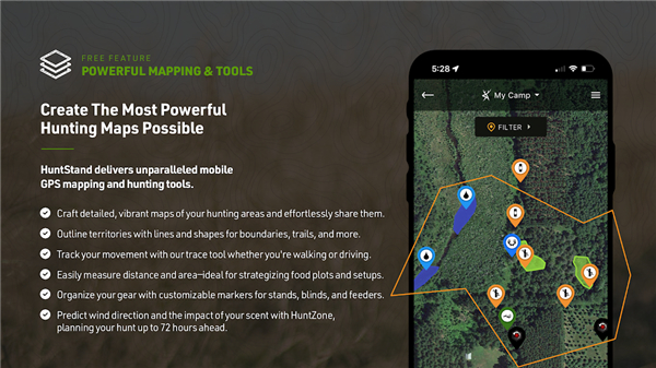
GPS Mapping and Live Tracker
Navigate terrain with high-accuracy GPS mapping that pinpoints your location in real time. Drop map markers to save tree stands, blinds, trail cameras, or game sightings. Track your path as you move through the field, helping you scout efficiently and return to key locations with ease.
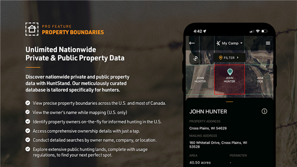
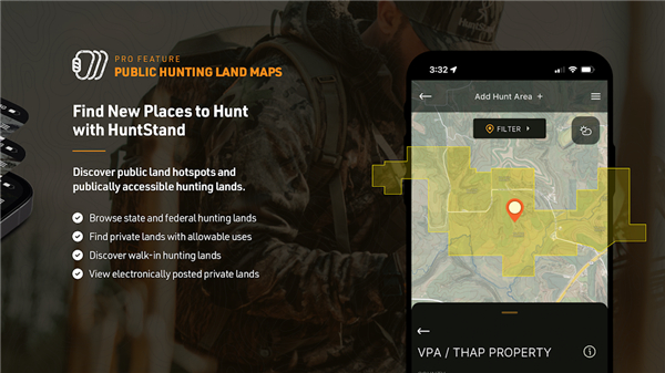
Nationwide Property Boundaries & Ownership Info
Access detailed property maps that show public and private land boundaries for all 50 states and most of Canada. Upgrade to HuntStand Pro to unlock searchable property owner details—perfect for verifying hunt access or contacting landowners.
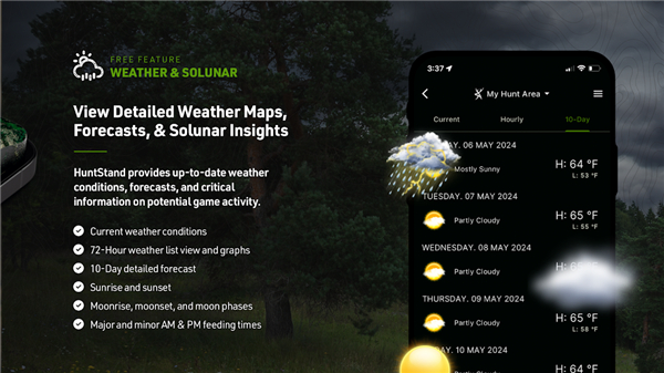
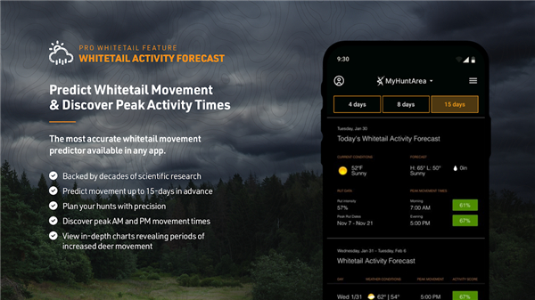
Whitetail Activity Forecasts
Receive a location-specific 15-day deer activity forecast based on environmental patterns, rut progression, and historical behavior. This exclusive tool helps hunters schedule trips for optimal chances at spotting movement during peak hours.
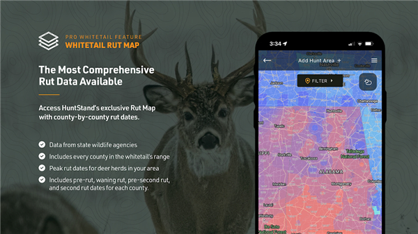
County-Level Rut Map
Visualize rut phases—pre-rut, peak-rut, post-rut—on a county-by-county color-coded map (U.S. only). Know when whitetail breeding behavior spikes, so you can adapt your strategy accordingly and increase success rates.
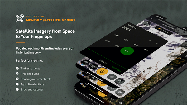
Monthly Satellite Imagery and Historical Archive
Scout smarter using fresh monthly satellite updates, combined with historical archives that reveal terrain evolution over time. Monitor crop rotations, timber changes, or water levels to identify consistent game corridors.
-------✦ COUNTRY OF ORIGIN AND LANGUAGE ✦------
Country: United States
Original Language: English
-------✦ RECOMMENDED AUDIENCES ✦------
HuntStand is crafted for serious hunters, land managers, and outdoor explorers who demand precision in their scouting and navigation.
Whitetail hunters will benefit from the specialized forecasts and rut data; backcountry adventurers will appreciate offline access and terrain awareness; and property owners or leaseholders will enjoy collaborative mapping and land boundaries.
-------✦ FREQUENTLY ASKED QUESTIONS (FAQ) ✦------
Q: Is HuntStand free to use?
A: Yes, the base app is free and includes core GPS features. Premium subscriptions unlock advanced maps and tools.
Q: Does HuntStand work without internet?
A: Absolutely. Users can download maps for offline use—ideal for remote hunts with no signal.
Q: How does the whitetail forecast work?
A: It uses location data and environmental trends to predict deer activity for the next 15 days, giving hunters strategic insight.
Q: Can I see who owns a property?
A: Yes, with HuntStand Pro, you can view ownership data and search property owners by name across all 50 U.S. states.
---------------------------------------
Contact us at the following sites if you encounter any issues:
Official Website: Here
Email: support@huntstand.com / customerservice@gsmorg.com (Developer)
Phone number: +1 469-912-7883
---------------------------------------
Version History
v8.0.37 — 25 Jun 2025
This update includes general improvements and minor bug fixes to keep things running smoothly. Update now for the best experience.
- AppSize36.26M
- System Requirements5.0 and up
- Is there a feeFree(In game purchase items)
- AppLanguage English
- Package Namecom.huntstand.core
- MD591bdb90ddbe3115ed0b80f41e38205c6
- PublisherGSM Outdoors
- Content RatingTeenDiverse Content Discretion Advised
- Privilege19
-
HuntStand: GPS Maps & Tools 7.6.2Install
36.26M2026-03-19Updated


7.6
7996 Human Evaluation
- 5 Star
- 4 Star
- 3 Star
- 2 Star
- 1 Star